Hello all.
I have a set of scripts that was running fine with the older 20km RAP
grids, for the calculation of DCIN. Since the change to the 13km grid
delivery in late June, those scripts no longer work. (Yes, the
necessary file naming strings have been updated.)
The fundamental operation in question seems to be the use of GDVINT to
interpolate to ZAGL, with the dread warning ‘[GDVINT 4] Warning--no
surface elevation grid exists.’ Even so, GDINFO shows:
247 220831/2100F000 0 NONE PRES
25+ years of writing these kinds of scripts, and I am now stumped. Any
thoughts on how to rectify would surely help.
Thanks,

Pat
It's always difficult to remotely diagnose issues... however, if GDINFO
can see the grid, then it is there... therefore, there are a couple
options..
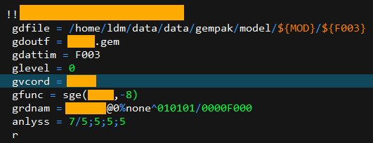
The simplest way is to identify the grid directly via gparm as I have
named a personal grid I create here in grdnam via gddiag... so in your
case simply substitute your parms as I have mine listed, and it should
see it.. elsewise, use gddiag to create your own grid to use in gdvint
then call the parms what you wish.. if gdinfo sees the grid, gddiag will
as well, since the same architecture is used.. personally, i love using
gddiag :)
cheers,

--patrick