- To: idvusers@xxxxxxxxxxxxxxxx
- Subject: Re: [idvusers] Change longitude where data from 2 geostationary satellites are merged together
- From: Don Murray <don.murray@xxxxxxxx>
- Date: Wed, 20 Jun 2012 12:44:28 -0600
Hi Dave-

On 6/19/12 11:44 AM, Dave Linder wrote:
Folks,

I am creating satellite images over the continental U.S. using a
combination of GOES-15 (west) and GOES-13 (east) data. I want to be
able to specify where the data sets are merged in the image (for
instance, let's say I want to merge the GOES-East and GOES-West data
along 105ºW). Is there a way to do this? I'm using McIDAS Area Files
from the CLASS database.

As always, thanks in advance!
Here's a Jython script that will allow you to resample the image to a new domain:
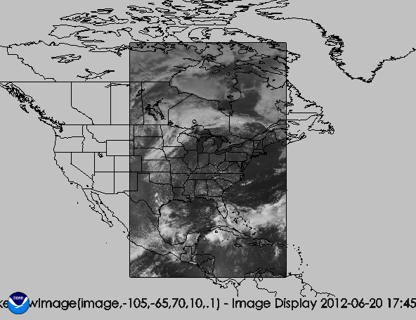
def makeNewImage(image,west,east,north,south,resolution):
   import visad.RealTupleType.LatitudeLongitudeTuple as llt
   numlons = int(abs((west-east)/resolution))
   numlats = int((north-south)/resolution)
   newDomain = makeDomain(llt,south,north,numlats,west,east,numlons)
   print newDomain
   return GridUtil.resampleGrid(image,newDomain,100)
(the 100 in the last line is a nearest neighbor resampling - omit if you want weighted average).
You could invoke it as:

makeNewImage(image,-105,-65,70,10,.1)
on a GOES-East image to resample it to -105,-65 and 10 to 70N at .1 degree resolution. Just pass in appropriate values for GOES-W. If you display them together, you can see the splice. Resulting display of GOES-E is attached.
McIDAS will do a better job, but this is a quick and dirty way.

Not sure if that helps, but it was a fun exercise for me. ;-)

Don
--
Don Murray
NOAA/ESRL/PSD and CIRES
303-497-3596
http://www.esrl.noaa.gov/psd/people/don.murray/
Attachment:
goesresample.png
Description: PNG image
- References: