- To: John Caron <caron@xxxxxxxxxxxxxxxx>
- Subject: Re: [netcdf-java] ncWMS and ellipsoid-support in CF-1.2
- From: Heiko Klein <Heiko.Klein@xxxxxx>
- Date: Thu, 25 Mar 2010 11:15:23 +0100
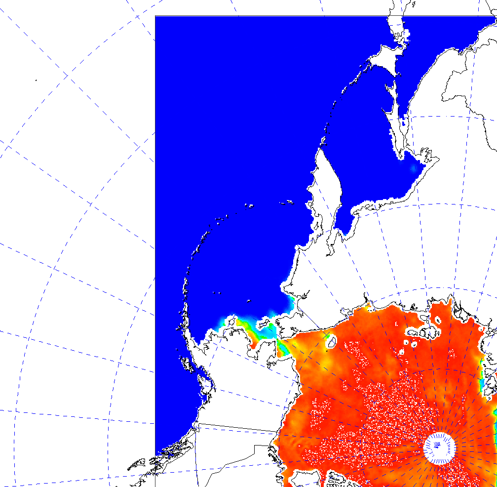
Hi John,

you can find an example file under:
http://pastebin.met.no/pastebin/cgi-bin/file?id=ccf557eaebc7d8757244577e9df70188914d3057/ice_conc_nh_200911291200_CF.nc

The file contains sea-ice concentrations at the north-pole including a
land mask. In the attached IDV-figure with McIdas borders, you can see
that the islands between North-America and Asia have a offset of approx.
20km (2cells) to where they should be.

I'm not 100% sure that the land-mask is correct. Usually I test those
against IDV, but this test failed now.

Best regards,

Heiko


On 2010-03-24 17:46, John Caron wrote:
> Heiko Klein wrote:
>> Hi Jon,
>>
>> I just found some time to look at the source of netcdf-java 4.1. As far
>> as I can see, only some projections (LambertConformalConicEllipse,
>> AlbersEqualAreaEllipse, UTM) support ellipsoids, while the others use a
>> constant spherical earth with EARTH_RADIUS = 6371.229km
>>
>> In particular, Stereographic projection doesn't support ellipsoids, so
>> this explains the offset in my maps.
>>
>> Would be nice to have this assured by one of the unidata-developpers. I
>> mainly checked the ucar/unidata/geoloc/projection sources.
>>
>> Best regards,
>>
>> Heiko
>
> Yes, correct. We are slowly adding ellipsoid support, but only after we
> have a sample dataset that uses them. We are porting code from proj4,
> its rather time-consuming to get it right.
> if you have sample data where the ellipsoidal earth matters, send it
> along, we'll get to it when we can. or, if you have resources and
> expertise to port the proj4j code, i could send that to you and get you
> started.
>
> John
>
>>
>> On 2010-03-10 14:38, Jonathan Blower wrote:
>>> Hi Heiko,
>>>
>>> This is a good question.  ncWMS relies on netcdf-java for converting
>>> coords to wgs84 lat lon, so I'm copying this to the mailing list in
>>> the hope that someone can enlighten me about ellipsoid support in the
>>> library.
>>>
>>> Cheers, Jon
>>>
>>> -----Original Message-----
>>> From: Heiko Klein <Heiko.Klein@xxxxxx>
>>> Sent: 09 March 2010 08:54
>>> To: Jonathan Blower <j.d.blower@xxxxxxxxxxxxx>
>>> Subject: ncWMS and ellipsoid-support in CF-1.2
>>>
>>> Hi Jon,
>>>
>>> I currently try to visualize some satellite ice-maps over the north-pole
>>> with ncWMS, but the data seems to be displaced by some 10-30km compared
>>> with the land-maps (generated by mapserver).
>>>
>>> While geo-tools and therefore ncWMS support lots of coordinate reference
>>> systems for the presented maps, the support for ellipsoids was only
>>> added to CF-1.2. Do you know if ncWMS already supports the CF-1.2
>>> features like semi_major_axis/semi_minor_axis for input-files, or does
>>> it assume the CF-1.0 spherical earth with 6371km radius?
>>>
>>> Best regards,
>>>
>>> Heiko
>>>
>>
>> _______________________________________________
>> netcdf-java mailing list
>> netcdf-java@xxxxxxxxxxxxxxxx
>> For list information or to unsubscribe, visit:
>> http://www.unidata.ucar.edu/mailing_lists/
>

--
Dr. Heiko Klein                              Tel. + 47 22 96 30 00
Development Section / IT Department          Fax. + 47 22 69 63 55
Norwegian Meteorological Institute           http://www.met.no
P.O. Box 43 Blindern  0313 Oslo NORWAY
Attachment:
offsetWGS_spherical.png
Description: PNG image
- References:
- Re: [netcdf-java] ncWMS and ellipsoid-support in CF-1.2
- From: Jonathan Blower
- Re: [netcdf-java] ncWMS and ellipsoid-support in CF-1.2
- From: Heiko Klein
- Re: [netcdf-java] ncWMS and ellipsoid-support in CF-1.2
- From: John Caron
- Re: [netcdf-java] ncWMS and ellipsoid-support in CF-1.2