Hello ncWMS e Thredds folks,
I made two test follow the cf-conventions. The first test, my netCDF file
is volumetric (bottom_top dimension = 1). My second test my file isn't
volumetric.
In second test, I can read my netCDF file with ncWMS, but for my first test
it isn't working for me.
Am I doing something wrong?
Following my netCDF headers:
*FIRST TEST: test_vol.nc <http://test_vol.nc>*
netcdf test_vol {
dimensions:
time = 1 ;
bottom_top = 1 ;
maxStrlen64 = 64 ;
south_north = 960 ;
west_east = 960 ;
variables:
double latitude(south_north, west_east) ;
latitude:standard_name = "latitude" ;
latitude:long_name = "latitude" ;
latitude:units = "degrees_north" ;
latitude:axis = "Y" ;
latitude:coordinate_defines = "center" ;
latitude:_CoordinateAxisType = "Lat" ;
latitude:missing_value = -999. ;
double longitude(south_north, west_east) ;
longitude:standard_name = "longitude" ;
longitude:long_name = "latitude" ;
longitude:units = "degrees_east" ;
longitude:axis = "X" ;
longitude:coordinate_defines = "center" ;
longitude:_CoordinateAxisType = "Lon" ;
longitude:missing_value = -999. ;
int azimuthal_equidistant ;
azimuthal_equidistant:grid_mapping_name = "azimuthal_equidistant" ;
azimuthal_equidistant:semi_major_axis = 6378137. ;
azimuthal_equidistant:inverse_flattening = 298.257223563 ;
azimuthal_equidistant:longitude_of_prime_meridian = 0. ;
azimuthal_equidistant:false_easting = 0. ;
azimuthal_equidistant:false_northing = 0. ;
azimuthal_equidistant:latitude_of_projection_origin = -25.505277633667 ;
azimuthal_equidistant:longitude_of_projection_origin = -50.3611106872559 ;
float DZ(bottom_top, south_north, west_east) ;
DZ:grid_mapping = "Azimuthal_Equidistant" ;
DZ:units = "dBZ" ;
DZ:standard_name = "reflectivity" ;
DZ:long_name = "reflectivity" ;
DZ:description = "Radar reflectivity" ;
DZ:coordinates = "longitude latitude" ;
DZ:missing_value = -999.f ;
}
*SECOND TEST: test.nc <http://test.nc>*
netcdf test {
dimensions:
time = 1 ;
bottom_top = 1 ;
maxStrlen64 = 64 ;
south_north = 960 ;
west_east = 960 ;
variables:
double latitude(south_north, west_east) ;
latitude:standard_name = "latitude" ;
latitude:long_name = "latitude" ;
latitude:units = "degrees_north" ;
latitude:axis = "Y" ;
latitude:coordinate_defines = "center" ;
latitude:_CoordinateAxisType = "Lat" ;
latitude:missing_value = -999. ;
double longitude(south_north, west_east) ;
longitude:standard_name = "longitude" ;
longitude:long_name = "latitude" ;
longitude:units = "degrees_east" ;
longitude:axis = "X" ;
longitude:coordinate_defines = "center" ;
longitude:_CoordinateAxisType = "Lon" ;
longitude:missing_value = -999. ;
int azimuthal_equidistant ;
azimuthal_equidistant:grid_mapping_name = "azimuthal_equidistant" ;
azimuthal_equidistant:semi_major_axis = 6378137. ;
azimuthal_equidistant:inverse_flattening = 298.257223563 ;
azimuthal_equidistant:longitude_of_prime_meridian = 0. ;
azimuthal_equidistant:false_easting = 0. ;
azimuthal_equidistant:false_northing = 0. ;
azimuthal_equidistant:latitude_of_projection_origin = -25.505277633667 ;
azimuthal_equidistant:longitude_of_projection_origin = -50.3611106872559 ;
float DZ(south_north, west_east) ;
DZ:grid_mapping = "Azimuthal_Equidistant" ;
DZ:units = "dBZ" ;
DZ:standard_name = "reflectivity" ;
DZ:long_name = "reflectivity" ;
DZ:description = "Radar reflectivity" ;
DZ:coordinates = "longitude latitude" ;
DZ:missing_value = -999.f ;
}
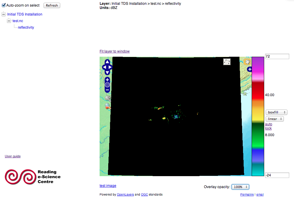
img in godiva (ncWMS)
[image: Imagem inline 1]
Regards,
*|||| ||||||||||**|**||| Marco Aurélio Silva Neto*
*|||| *IIIIIIIII*||**||| *Analista de Sistemas
*||||||||||||| ||||| **Fone*: (41) 3320-2000 - Ramal: 2079
2014-02-25 4:44 GMT-03:00 Jon Blower <j.d.blower@xxxxxxxxxxxxx>:
> Hi Marco,
>
>
>
> The CF conventions tell you how to encode an azimuthal equidistant
> projection (although I don't think they provide an example). Go to
> http://cf-pcmdi.llnl.gov/documents/cf-conventions/1.6/cf-conventions.htmland
> search for "azimuthal".
>
>
>
> Someone else on this list may have an example that is known to work. (If
> they do, could I please have a copy for the ncWMS test suite?)
>
>
>
> Good luck,
>
> Jon
>
>
>
> *From:* MNETO (simepar) [mailto:mneto@xxxxxxxxxx]
> *Sent:* 24 February 2014 20:42
> *To:* thredds@xxxxxxxxxxxxxxxx; ncwms-users@xxxxxxxxxxxxxxxxxxxxx;
> thredds-join@xxxxxxxxxxxxxxxx
> *Subject:* [Ncwms-users] Azimuthal Equidistant Projection
>
>
>
> Hello ncwms and thredds folks,
>
>
>
> How can I inform the projection of my data in netcdf file. My data are
> azimuthal equidistant projection.
>
>
>
>
>
> Regards,
>
>
>
>
> *|||| |||||||||||||| Marco Aurélio Silva Neto*
>
> *|||| *IIIIIIIII*||||| *Analista de Sistemas
>
> *||||||||||||| ||||| **Fone*: (41) 3320-2000 - Ramal: 2079
>
>
>
> _______________________________________________
> thredds mailing list
> thredds@xxxxxxxxxxxxxxxx
> For list information or to unsubscribe, visit:
> http://www.unidata.ucar.edu/mailing_lists/
>