- To: thredds community <thredds@xxxxxxxxxxxxxxxx>
- Subject: [thredds] Help with WMS vector style
- From: tom cook <tmcook@xxxxxxxx>
- Date: Wed, 16 Apr 2014 10:04:39 -0700
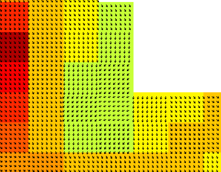
HI,
I'm using the following WMS call

http://myserver:8080/thredds/wms/HFRNet/USWC/6km/hourly/RTV?LAYERS=surface_sea_water_velocity&ELEVATION=0&TIME=2014-04-15T00%3A00%3A00.000Z&TRANSPARENT=true&STYLES=vector%2Frainbow&CRS=EPSG%3A4326&COLORSCALERANGE=-0.5%2C0.5&NUMCOLORBANDS=20&LOGSCALE=false&SERVICE=WMS&VERSION=1.1.1&REQUEST=GetMap&FORMAT=image%2Fpng&SRS=EPSG%3A4326&BBOX=-118.63619699146,33.586096075485,-118.24135621692,33.894565430591&WIDTH=768&HEIGHT=600

and get back the attached figure.

My problem is that this is data gridded to a 6km resolution, but
vectors are returned at ~1km resolution. Is there anyway to change
this behavior in the WMS call? It doesn't seem like there are any
applicable settings in the wmsConfig.xml or catalog.xml.

Thanks,
Tom
Attachment:
RTV-vector.png
Description: PNG image
- Follow-Ups:
- Re: [thredds] Help with WMS vector style
- From: Ivan Price
- Re: [thredds] Help with WMS vector style