- To: tom cook <tmcook@xxxxxxxx>, thredds community <thredds@xxxxxxxxxxxxxxxx>
- Subject: Re: [thredds] Help with WMS vector style
- From: Ivan Price <Ivan.Price@xxxxxxxxxxx>
- Date: Thu, 24 Apr 2014 08:43:46 +0000
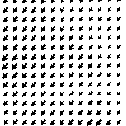
Hi Tom

about a year ago i did some modifs to the ncwms code used in thredds to enable
some better control via the URL, namely a scale factor for changing the size of
the arrows as a function of the amplitude (not what you'r talking about here
though i realise)

unfortunately (embarassingly) i struggled with git to not consider mixed line
endings as new code and hence the modifs where never submitted for
consideration by ncWMS/thredds people.

(i believe that) the relevant code is here:
https://github.com/Unidata/ncWMS/blob/master/src/java/uk/ac/rdg/resc/ncwms/graphics/ImageProducer.java

and it's the stepScale and vectorScale that should be parameterisable from the
URL.. from what i understand you want to touch the stepScale, currently you see
this is derived from vectorScale (unless someone more knowledgable corrects me
!). in fact i think you want the step to be linked to ground units instead of
pixel units which is more complex i guess.

i'd be happy to send you the (minor) mods i made if they'd be useful, although
they didn't address your exact requirement.

-i


-----Message d'origine-----
De : thredds-bounces@xxxxxxxxxxxxxxxx [mailto:thredds-bounces@xxxxxxxxxxxxxxxx]
De la part de tom cook
Envoyé : Wednesday, 16 April 2014 19:05
À : thredds community
Objet : [thredds] Help with WMS vector style

HI,
I'm using the following WMS call

http://myserver:8080/thredds/wms/HFRNet/USWC/6km/hourly/RTV?LAYERS=surface_sea_water_velocity&ELEVATION=0&TIME=2014-04-15T00%3A00%3A00.000Z&TRANSPARENT=true&STYLES=vector%2Frainbow&CRS=EPSG%3A4326&COLORSCALERANGE=-0.5%2C0.5&NUMCOLORBANDS=20&LOGSCALE=false&SERVICE=WMS&VERSION=1.1.1&REQUEST=GetMap&FORMAT=image%2Fpng&SRS=EPSG%3A4326&BBOX=-118.63619699146,33.586096075485,-118.24135621692,33.894565430591&WIDTH=768&HEIGHT=600

and get back the attached figure.

My problem is that this is data gridded to a 6km resolution, but vectors are
returned at ~1km resolution. Is there anyway to change this behavior in the WMS
call? It doesn't seem like there are any applicable settings in the
wmsConfig.xml or catalog.xml.

Thanks,
Tom
Attachment:
wms.png
Description: wms.png
- References:
- [thredds] Help with WMS vector style
- From: tom cook
- [thredds] Help with WMS vector style